

Marathon (M)
Overview
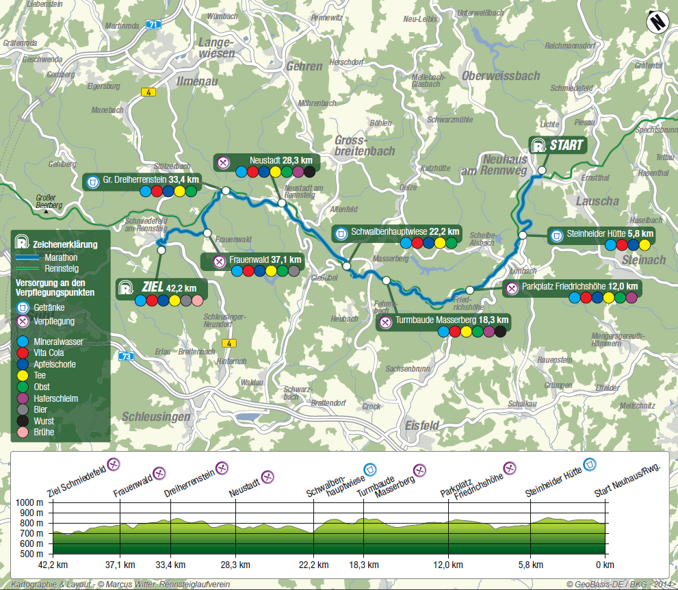
| Distance: | 42.2 km | |
| Start location: | Neuhaus am Rennweg – Apelsberg (820 m above sea level) | |
| Start time: | 9:00 a.m. | |
| Finish location: | Schmiedefeld am Rennsteig (711 m above sea level) | |
| Finish closing time: | 6:00 p.m. | |
| Entry fee: | Graduated price scale as per Race Announcement Dates: by 31 Oct / 31 Mar / 17 May |
Course Map
![]()
Details and Course Profile / OutdoorActive
Course Description
Before the starting shot is fired in the area outside GutsMuths-Hall in Neuhaus, the crowd will first sing and sway to the music. A tradition – no marathoner will set out on the course unless there has been the “Snow Waltz” – an unparalleled atmosphere.
Firing the starting shot, WSV Neuhaus winter sports club each year sends about 3,000 runners through the large four-metre-wide starting gate onto their 42.2 km route to Schmiedefeld.
From the starting area the race initially enters the “narrow” street leading out of Neuhaus. There is a nearly 6 km stretch to be run on a road surface before, after the first drink station at “Sandwieschen” (km 5.81 / 777 m above sea level), the race continues on a forest trail. At km 10.63 participants reach the first food station at “Dreistromstein” (812 m), which is looked after by WSV Scheibe-Alsbach winter sports club.
Refreshed, participants tackle uphills and downhills towards “Eisfelder Ausspanne” (km 15.76 / 752 m) and from there continue uphill to the highest elevation of the Marathon course, the “Eselsberg” (km 18.3 / 841 m) with its Rennsteigwarte observation tower, a landmark on the Rennsteig trail. A food station is set up here by SG “Rennsteig” Masserberg sports group and there is split timing.
Now the route is downhill. When crossing the road at Rennsteighaus (km 19.25 / 785) runners have already tackled a 56 m elevation change.
Passing the meadow behind Masserberg the race moves towards the next drink station at Schwalbenhauptwiese (km 22.2 / 703 m), where Wanderverein Schleusegrund hiking club distributes refreshments. But participants need to be alert. Before arriving at the drink station they have to tackle a hollow-way downhill over rough and smooth and roots. A real cross-country trail indeed.
In parallel with the road the Rennsteig leads towards Neustadt. The route crosses the road at Kahlert über den Tannengrund and then continues to where it enters Neustadt. On the fairground there is the food station (km 28.3 / 805 m) set up by Laufgruppe Neustadt runners group.
Following the refreshment the climb via Großer Burgberg (818 m) can now be tackled. It is a steep uphill and tends to be taken at walking pace. But the next drink station at “Dreiherrenstein” (km 33.4 / 810 m), which is looked after by IG Stützerbach, is not far away.
From there, the route is slightly downhill towards Frauenwald. At the “Monument am Bohrstuhl” (km 37.1 / 786 m) Frauenwälder SV sports club distributes a last refreshment to the runners. Those who wish may have a “sip” of Köstritzer Schwarzbier black lager beer here as an energy boost for the last few kilometres to Schmiedefeld.
Schmiedefeld, the finish – just across the level crossing and a left turn into “Reitallee” street. The uphill to the sports ground from 622 m above sea level to 711 m above sea level is a real challenge for every marathoner.
The finish area buzz can be heard already. The final stretch of the course lined by a big crowd of cheering spectators, every runner will go all-out. Just half a lap to go and then cross the finish line.
Elevation Difference
| Total uphills: | 637 m | |
| Total downhills: | 706 m | |
| Elevation difference: | 1.343 m | |
| Highest location: | Turmbaude Masserberg (841 m above sea level) | |
| Lowest location: | Schmiedefeld, Reitallee junction (622 m above sea level) |
Register Online
Please read the respective Race Announcement before registering!

